
Title
ArcGIS ToolBox for Mohammed Bin Rashid Space Centre
Overview
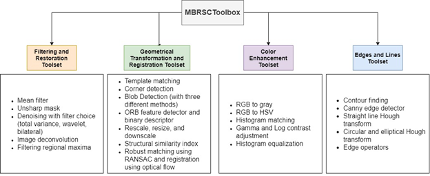
The purpose of this project is to develop toolbox for MBRSC within ArcGIS software, these tools will be tested on DubaiSat-2 and KhalifaSat images. MBRSC toolbox includes three different toolsets: Color Enhancement, Edges and Lines, Geometrical Transformations and Registration, and Filtering and Restoration.
Methodology
Related Projects

A Low Cost, Efficient Electrical Power System Design for CubeSat
Coronavirus (COVID-19) consider as worldwide major health problem. According to UAE Ministry of health, COVID-19
Flight Software Design and Implementation for a CubeSat
Coronavirus (COVID-19) consider as worldwide major health problem. According to UAE Ministry of health, COVID-19
Air Quality Management Zonation using Spatial-Temporal Statistical Analysis, Dubai-UAE
Coronavirus (COVID-19) consider as worldwide major health problem. According to UAE Ministry of health, COVID-19
Spatiotemporal Analysis for COVID-19 Dynamic Spread, Dubai – UAE
Coronavirus (COVID-19) consider as worldwide major health problem. According to UAE Ministry of health, COVID-19