
Title
Geo-statistical Seismic analysis, and Vulnerability Assessment, UAE
Overview
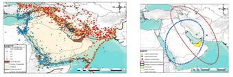
Assessing and analyzing the spatial distribution of earthquake events aids in identifying the presence of clustering and reveals hot and cold spots across the study area. Combining the spatial analysis of earthquake events with other geographical and geophysical parameters leads to more understanding of the vulnerability of critical infrastructure and the demographics of the affected population. Where vulnerability investigation and assessment are important for earthquake crises limitation and mitigation. This research used Geographical Information Systems (GIS) to examine the spatiotemporal occurrence of earthquake events throughout the Arabian plate and their effect on the United Arab Emirates (UAE). Spatial pattern analysis techniques, including Moran I and Getis–Ord Gi*, were applied to 115 years of earthquakes (1900-2015) that have occurred throughout the Arabian plate. The directional distribution (standard deviational ellipse) of earthquake magnitudes was analyzed to determine the spatial characteristics and the directional tendency of the earthquakes throughout the Arabian plate. Afterword, geophysical parameters of UAE, specifically Peak Ground Acceleration (PGA), fault line distance, slope, soil type, and geology were ranked, weighted based on its contribution and combined using an Analytic Hierarchy Process (AHP) to identify and locate seismic hazard zones. The resulted Seismic Hazard Zonation Map (SHZM) was classified to five hazard zones ranging from very high to very low.
Methodology
Finally, GIS methodology has been established to evaluate urban vulnerability through a spatial multi-criteria analysis, where different factors that affect the vulnerability of Fujairah- UAE are evaluated, ranked and weighted according to its importance and influence in identifying the city vulnerability. It has been found that Fujairah emirate sited in the “very High” zone, Sharjah and Dubai cities located from “High” to moderate zones while Abu Dhabi city stands relatively far from seismic hot spots and major faults and placed in the low seismic hazard zone. Moreover, three locations within Fujairah have been identified as the most vulnerable areas, were the population density is high and there is a shortage of open areas as well as relief centers.
Results
The results of this study could help improve urban planning and emergency mitigation strategies in UAE, and Fujairah emirate.
Related Projects

A Low Cost, Efficient Electrical Power System Design for CubeSat
Flight Software Design and Implementation for a CubeSat
Air Quality Management Zonation using Spatial-Temporal Statistical Analysis, Dubai-UAE