
Title
Photogrammetric Techniques and UAV for Drainage Pattern and Overflow Assessment in Mountainous Terrains- Hatta/UAE
Overview
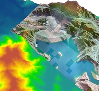
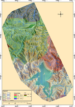
Accurate and precise spatial hydrologic information is essential for effective management of natural resources, planning, and disaster response. Very high-resolution images and precise digital elevation models (DEMs) are crucial to accurately predict overflow in urban and mountainous regions; however, available course resolution DEMs with insufficient details cannot provide reliable overflow models. In this context, unmanned aerial vehicles (UAVs) offer a competitive alternative over satellites or airplanes and provide high spatial details essential for significant improvement of hydrological modeling. In this study, photogrammetric processing that includes stereo images captured via a fixed-wing drone were processed to generate a high-resolution DEM for the area surrounding the Hatta Dam in the United Arab Emirates. hydrologic modeling was developed to show that flow modeling based on the UAV DEMs resulted in accurate hydrological modeling.
Results
Related Projects

A Low Cost, Efficient Electrical Power System Design for CubeSat
Flight Software Design and Implementation for a CubeSat
Air Quality Management Zonation using Spatial-Temporal Statistical Analysis, Dubai-UAE