
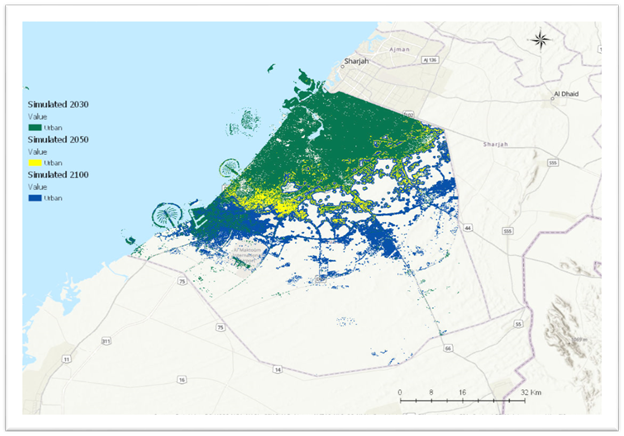
Figure: Dubai’s Land Use Land Cover simulation
Title
Multi Temporal Satellite Images for Growth Detection and Urban Sprawl Analysis; Dubai
Overview
Urbanization is a spatial-temporal process that has significant role in economic, social, and environmental structures. Spatio-temporal analysis for urban growth is vital for city management planning. With highly recognized financial and social developing trends, Dubai city-UAE appears as one of most challenging cities in terms of research and preparation towards a smart city aspect.
Methodology
In this study Landsat multi-temporal, medium-resolution images were used to detect, and analyze the urbanization trend in Dubai over the last three decades (1986-2019). Moreover, the impact of urbanization on the aspects of smart city tendency is investigated. The purpose of this study is to use high and medium-resolution remote sensing images that integrate DS-1, DS-2, and Landsat images in order to examine the urbanization of Dubai city for the last three decades (1986-2019), along with its impact on Land Cover Land Use (LCLU) and transportation towards smart city aspects.
Results
Related Projects

A Low Cost, Efficient Electrical Power System Design for CubeSat
Coronavirus (COVID-19) consider as worldwide major health problem. According to UAE Ministry of health, COVID-19
Flight Software Design and Implementation for a CubeSat
Coronavirus (COVID-19) consider as worldwide major health problem. According to UAE Ministry of health, COVID-19
Air Quality Management Zonation using Spatial-Temporal Statistical Analysis, Dubai-UAE
Coronavirus (COVID-19) consider as worldwide major health problem. According to UAE Ministry of health, COVID-19
Spatiotemporal Analysis for COVID-19 Dynamic Spread, Dubai – UAE
Coronavirus (COVID-19) consider as worldwide major health problem. According to UAE Ministry of health, COVID-19